My name is Ethan Rudd, and I am currently a student studying journalism and political science at the University of Cincinnati. I formerly attended Wilmington College and I am a graduate of Felicity-Franklin High School. This blog is the culmination of my interest in writing, and the need I feel to practice writing so that I can be a better student and gain valuable experience. Hopefully the things I choose to share will generate some interest; I do not plan to focus my writing on any specific subject–rather I plan to write about a variety of topics that I feel I can contribute valuable input to.
Are you someone who wishes there were more creature-feature throwback films with good modern production values? Well, I guess Halloween came early for you because that’s what director John Krasinsksi’s “A Quiet Place” is.
“A Quiet Place” is a solid monster movie. It checks all the boxes. Scary monsters with unique abilities? Check…the monsters here are weird hunter-killers that rely on sound alone to hunt prey. Tense and suspenseful moments? Check…the film creates great tension through sound or the lack thereof. It’s so effective that you forgive the movie for its jump scares. They feel earned instead of shoehorned it. And all the hunter/prey moments the movie captures are good. Did you like the part in Jurassic Park where the raptors are hunting everyone? You’ll love this movie.
I also appreciate the world building in “A Quiet Place.” The opening scene works well. In two minutes (roughly, maybe) viewers are introduced to a post-apocalyptic world and Krasinski’s survivor family. You learn most of what you need to know without dialogue (there’s hardly any in the whole movie) and then, boom, monster shows up, the title card rolls and things are moving. This pace is maintained throughout the entire film; it doesn’t outstay its welcome and it doesn’t waste much time. Additionally, panoramic shots from atop a grain silo allow viewers to create a map in their head of the movie’s set pieces. This is a small, but appreciated detail when things eventually start to get hectic and you can still follow where characters are.
There are plenty of other little details that viewers can appreciate, too. Kids play monopoly with knitted play pieces to reduce sound. Characters create paths with sand to reduce the sound of footsteps. Krasinski’s family operates in a way that makes sense. But you can nitpick details too. Like how much noise is too much noise? You’d think it’d be impossible to live in this world. A raccoon gets turned to red paste just for squeaking. I guess you can’t cough or sneeze either. And how does Krasinski maintain electricity on the farmstead his family holes up in? Batteries? Generators? Couldn’t those things make noise? Why does Emily Blunt’s character get pregnant when she knows a loud baby could doom her entire family? That can almost be forgiven though because it sets up what might be the movies best scene when she is forced to deliver her baby in clear and present danger. And why is there a brainstorm dry-erase board in Krasinski’s barn bunker with random monster thoughts? It doesn’t tell us anything we don’t know. It says something like “Armor? Hearing? WHAT IS THEIR WEAKNESS?” Yeah, we get it. We learned all that stuff in the first two minutes of the movie…but the camera still chooses to focus on it at two separate times (including one critical moment) in the movie.
Regardless, the acting here is good. Blunt and Krasinski are solid and the movie is held up by Millicent Simmonds and Noah Jupe—the child actors. There’s no overacting here. No extra cheese. It’s all action/reaction. There’s also a surprising emotional resonance to “A Quiet Place.” This movie becomes less about monsters and more about how far parents are willing to go to protect their family. That allows the movie to grow beyond its horror tropes.
Final Verdict: This movie is riding a big hype train right now. It will be impossible to satisfy everyone. The tropes here are familiar, but the execution is unique. It’s definitely worth seeing if you’re a fan of the genre. This is a horror movie that isn’t afraid to be creative and shun dialogue in favor of noiseless tension. And it has a nice, simple story that doesn’t lose itself along the way.
A headstone perched on the bank of Redoak Creek in the Old Ripley Cemetery.
Walk down little used paths though fields, gravel lanes, or small country villages and you’ll find them—the generations-old stones that serve to keep the memory of the dead.
Cemeteries can be taken for granted. They can be found everywhere people live and people aren’t likely to think about them until they actually need a cemetery. When people do visit cemeteries or buy grave plots, they expect their local cemeteries to be taken care of.
Inactive cemeteries that no longer generate revenue through grave sales can be abandoned. When they are, city, village or township officials become responsible for maintaining them. According to the Ohio Revised Code that means keeping cemeteries mowed, but some concerned citizens say that’s not nearly enough.
Also, local governments may have limited resources when they inherit the responsibility of caring for additional cemeteries. It may be important to save what’s left of some cemeteries because corresponding records may be lost or destroyed over time—that means the memory of a person may just disappear, which provides significant roadblocks for historians and people interested in genealogy.
The marker of a Revolutionary War veteran. (Ripley)
A Grand Army of the Republic star, the marker of Civil War Veterans. (Franklin Township)
A Spanish-American War marker for a veteran’s grave. (New Richmond)
A grave marker for a World War I veteran. (New Richmond)
These issues are especially significant in rural cemeteries. Often, in rural areas, local governments have less to spend on cemetery upkeep. In some places, cemeteries have changed hands from the care of churches and religious groups to the care of township, village and city officials, who may only have enough resources to keep cemeteries mowed. As a result, inactive cemeteries have been neglected and even active cemeteries show sign of neglect.
Restoring cemeteries can also be a complex process. Certain types of headstones can only be fixed using certain products, and some headstones are in such bad shape that they require the attention of experts or stonemasons.
Restoration work is sometimes left to concerned citizens and volunteers. It appears that there are no quick and easy fixes when it comes to maintaining neglected cemeteries.
New Richmond: Reason for Concern
Greenmound Cemetery in New Richmond rests on a sloping hill overlooking the Ohio River.
After Bill Marsh retired from IBM as senior programs manager he looked for things to do in his village to stay active. In New Richmond that meant help keeping the riverfront clean. Eventually, the village administrator and the mayor asked Marsh if he’d be interested in looking at Greenmound Cemetery, a 15-acre plot situated on a sloping hill at the edge of the village. It has been active since the mid 1800s.
When Marsh and other volunteers explored the cemetery, they found toppled headstones and crumbling roads. In some places, they couldn’t tell where some of the stones were supposed to be.
Naturally, Marsh went to village hall to search through records so that he could match names with plots. “That’s when I found their records were in terrible shape,” Marsh said. “They lost a lot of records.” A fire in the 1970s destroyed some of the records, and the surviving records were not maintained properly, according to Marsh. Some of the surviving records have names but no locations.
“I spent a lot of time getting queries from people wanting to find their relatives,” Marsh said. “In some cases, I dug through and I found things for them. But in other cases, the records aren’t there.”
To help preserve what’s left of the existing records, Marsh offered to digitize what he could.
“That’s a big part of what needs to be done,” Marsh said. “To continue that process of trying to match up a location of a monument within the cemetery and assigning it an address—a location.”
New Richmond resident Bill Marsh (above) volunteered his time to work in village cemeteries as a member of a cemetery board. He still has binders full of copies of plots, deeds and maps.
Additionally, he did his best to try to plot out the village’s cemeteries digitally. He did this, however, without survey equipment on hills. Still, the process helped give him a rough estimate about how large the cemeteries are and how individual plots fit within them.
Eventually, Marsh and other volunteers formed a village cemetery board.
“I started going every time they had an interment,” Marsh said. “I was looking at the traffic flow going through the cemeteries and the problems associated with that.”
To ensure better future practices, Marsh created a 25-page document of systems and procedures for the cemetery. “I tried to set some rules down to follow and created some manual documents to fill out when they had interments,” he said.
But the future is still uncertain. A village cemetery levy failed in 2014. Marsh ended up being the last member of the cemetery board. The workload went beyond what he could do and he was unable to secure software to further pursue his digitization efforts.
The situation has improved. Marsh estimates he and other volunteers reset nearly 800 stones, although many of those were not permanent fixes—these people are volunteers, not stone masons or restoration experts. Some of the road in Greenmound was repaved.
According to Marsh, more permanent fixes require more investment. “You really need professional people to come in and put in an appropriate foundation underneath (headstones),” he said. “When you’re talking about some of the weights of these stones, they’re very big.”
He’s worried maintenance functions might be neglected in the future, too. The Ohio Revised Code stipulates minimum standards for maintaining cemeteries, but responsibilities other than mowing aren’t spelled out. “That’s nowhere near what you should do,” Marsh said.
In April, Marsh ended his activity as a volunteer. “I can’t continue to beat a dead horse,” he said.
Franklin Township: Lost and Found
Mt. Olive Cemetery is nearly hidden down a country lane, through a field and in a clearing in the woods. The marker for the cemetery is shown above.
Mt. Olive cemetery looks like what you’d imagine an old cemetery should look like. The cemetery is hidden down a country lane, through a field and in the woods. Yucca plants grow in bunches beneath massive cedar trees. A blanket of orange and brown leaves cover the plot.
There’s also the fact that Mt. Olive cemetery is old: it dates to 1795, nearly a decade before Ohio became a state.
But it didn’t always look like that way until recently. It had been all but forgotten because it became landlocked by private properties. A road that was plotted to the cemetery was never developed and it became out of sight. As a result, the cemetery became overgrown.
More recently, however, someone brought it to the attention of Franklin Township trustees and the Franklin Township Historical Society that there were headstones in the woods.
Franklin Township Historical Society president Jim Shafer initially assumed there were thirty or forty headstones in Mt. Olive. Instead, he and other volunteers found more than 300 graves on a plot of land that was much bigger than it was originally predicted to be.
Shafer and the volunteers spent six months removing dead trees, probing the ground for buried headstones, up righting headstones and trying to match names with graves.
Stone by stone, the cemetery was reclaimed from the forest. “When you start up righting the stones it’s like flowers coming up out of the ground,” Shafer said.
Franklin Township Historical Society president Jim Shafer at Smyrna Cemetery, the location of this past summer’s restoration work.
In the end, the volunteers reseeded the plot and erected a split rail fence. Shafer estimates the cemetery had been abandoned for 60 years. “We have to start somewhere,” Shafer said. “The sad part is we’re starting 80 years too late. We’re trying to get copies of deeds for the cemeteries, plots of the cemeteries and any information we can find.”
The project was funded by the Franklin Township Historical Society and it showed what could be accomplished. Last year, Franklin Township passed a cemetery levy, which will help continue restoration work.
That work is needed, according to Shafer. There are 10 cemeteries in the township and only three of those are still active. That means there are seven cemeteries that require maintenance that don’t generate revenue from grave sales.
Dusk falls on a farm adjacent to Mt. Olive Cemetery, which became landlocked by private property.
Smyrna Cemetery is one such cemetery. “It was in dire need of restoration work,” Shafer said. Headstones were leaning or had fallen over. Additionally, after probing the ground at Smyrna, volunteers found that the cemetery plot was larger than what they had anticipated.
A section of the cemetery that had become overgrown and not maintained ended up concealing buried headstones, including the headstone of a black World War II veteran. There are also multiple black Civil War veterans buried in Smyrna.
There were also headstone bases with no stones. “Apparently, there had been a previous restoration many, many years ago and in order to stabilize some of the bigger stones they busted up smaller stones and used them as foundation material,” Shafer said. “It really disgusted me.”
Once again, the volunteers did their round of restoration work. One of the biggest challenges was trying to match stones that had been moved with their original locations—the records for some of the inactive cemeteries no longer exist.
Now, Shafer says they have enough work to keep them busy for the next five years.
“This is our home,” Shafer said. “These are our cemeteries. We put monuments up so we don’t forget people. But we do forget.”
Ripley: Some help, some hope
The headstone of Revolutionary War veteran and Ripley founder James Poage.
History is important to the village of Ripley. Industry has left this part of the river valley, and tobacco—the valley’s cash crop—is no longer a cash crop. Instead, Ripley hopes to attract business through tourism now. The small village boasts several museums, including the houses of abolitionists John Parker and John Rankin. Preserving what remains of the past is important.
“What we have is our history,” Ripley Heritage Inc. president Betty Campbell said. “That’s what we have to utilize.”
Ripley Heritage Inc. is a non-profit organization dedicated to the preservation of the Rankin House and the Ripley Museum. Campbell became interested in doing restoration work in the Old Ripley Cemetery, a small plot of land on the banks of Redoak Creek hidden on a gravel road behind a row of houses. Three Revolutionary War veterans are buried there, including the founder of Ripley, James Poage.
My Movie 1 from Ethan Rudd on Vimeo.
Headstones rest on high creek banks at Old Ripley Cemetery. In some spots toppled headstones huddle together. In the center of the cemetery, headstones stick out of an old tree trunk.
It all seemed like too much for Campbell and a modest group of volunteers, so she ended up contacting Misti Spillman, the director of the Preble County Historical Society.
Spillman was a member of AmeriCorps through the Oho Historical Society and accumulated experience in cemetery restoration work. She still sets up workshops for groups that contact her.
The workshops provide a crash course in beginner’s restoration work. “I treat it like a beginner’s workshop for equipment use and proper mortar mixes and adhesives,” Spillman said. “But I also tell them what not to do.”
When Spillman teaches people what not to do she reiterates that you want to do no further damage to the site. Still, she’s heard of people using power washers, chemicals and power tools on headstones. Instead of using the proper mortar mixes and epoxy, some people use cement to fix cracks in stone, which becomes more brittle than the stone itself, making it susceptible to breaking. Those methods are invasive and can damage stones permanently.
Instead, Spillman advocates for using more non-invasive methods that often require more time and patience. She’s even used toothbrushes to clean headstones. “I always tell people if you’re not sure, don’t do it,” Spillman said. “You have to have a lot of patience to do this.”
The cost of a workshop covers the materials Spillman uses for a hands-on tutorial. In Ripley, that meant resetting the base of a leaning headstone at Old Riley Cemetery and cleaning the stone itself.
The workshop led to work that has just scratched the surface of what could be done in Ripley, according to Betty Campbell. She hopes, however, that the workshop will have an impact in other rural areas. “People came from other communities to see our workshop and then took that information back to their communities and their little country cemeteries,” she said.
It was an encouraging sign for Campbell. It meant that other people, like herself, care about respecting the past.
Monarch butterflies are an easily recognizable species, but now they are also a species under threat.
According to the National Wildlife Federation monarchs have experienced a 90 percent decrease in population size in the past 20 years.
That decrease, and a loss of habitat, threatens monarch migratory patterns too.
That’s why Hamilton County Park environmental educator Adam McCosham (Mc-kosh-am) led a catch and release tagging event at Shaker Trace Nursery on Sunday.
The program uses unique ID stickers to tag monarchs to track their movements.
That data benefits researchers who are trying to understand the survivability rates of certain areas.
McCosham says the results are important to understanding not only the plight of the monarch, but other pollinators too.
Monarch butterflies have experienced a steady decrease in population size for the past 20 years, putting the future of a species and a phenomenon at risk.
The phenomenon at risk is the monarch’s migratory behavior, which makes them unique in the butterfly world.
Every year, around the beginning of October, monarchs begin to make the long trek south towards Mexico and the California coast where they roost.
But the same factors threatening monarch populations also pose the risk of disrupting their winter homes.
That’s why Adam McCosham, a Hamilton County Parks employee who serves as an environmental educator, led members of the public on a catch-and-release tagging event at Shaker Trace Nursery on Sunday.
Armed with butterfly nets, McCosham’s group attempted to catch monarchs, tag them with a unique ID sticker, and release them.
The hope is that when the butterflies reach their destination someone will notice the tag and record it to contribute to data that may prove helpful to researchers.
“You can see exactly where they’re going,” McCosham said. “You can also track survivor trends as well, like what areas are getting better survivability.”
Habitat loss impacts monarchs perhaps more than any single other factor.
The same flat land that attracts butterflies to open meadows are also attractive to developers.
Changing agriculture practices also impact the amount of milkweed readily available to monarchs, which they depend on for food and reproductive purposes.
“The thing that affects them the most here is genetically modified crops,” McCosham said.
McCosham caught the first monarch with a flick of the wrist near a row of purple aster flowers, folding the net over itself and trapping the insect.
He then removed the butterfly, attached a unique tracking sticker, and released the butterfly, now designated “XHL700.”
After the release, he records the date, the monarch’s gender, the unique ID, and the location of the catch on a sheet he will send to a lab in Kansas that will tabulate the date.
In total, McCosham’s group caught three monarchs.
“I had low expectations today,” he said. “Honestly, I didn’t know if we’d get any. We’re a little past their peak season.”
McCosham’s words echo underlying concerns he voices later, before his group of volunteers leave.
“Insects in general are important because they pollinate a lot of our food supply,” he said. “Monarchs could be an indicator—a keystone species—of pollinators plight.”
After University of Cincinnati sophomore midfielder David Sanz delivered a hard cross that was initially blocked by Indiana University-Purdue University Indianapolis goalkeeper Michael Buck there was a scramble for the loose ball.
The Bearcats and Jaguars bunched together in the box, colliding at the ball for a brief instant.
Finally, UC freshman forward Austin Smythe emerged from the scrum galloping towards the sideline with arms outstretched.
Goal.
Smythe’s goal, which came in the 62nd minute, proved to be the game-winner for the Bearcats in their 2-1 come from behind victory over IUPUI Friday night.
“I was happy to be in the right spot at the right time and tap it in,” Smythe said.
Trailing 1-0 at halftime, the Bearcats opened the second half much more aggressively by altering their formation to better facilitate up-tempo play.
“I thought we started out very slow,” UC head coach Hylton Dayes said. “We knew we had to change our shape and we had to basically chase the game.”
Usually the Bearcats like to control games by possessing the ball, but a stingy IUPUI team and inclement weather forced them to change to a 4-4-2 formation.
Lingering rain showers from the aftermath of Hurricane Harvey soaked the playing field creating dead spots in some places where the ball would stop suddenly after shooting up small water geysers.
Exasperated players on both teams were puzzled by the balls unpredictability in certain corners of the field, causing them to avoid some spaces altogether.
The Bearcats adjustments at halftime payed off in the 55th minute when Sanz sliced a shot from the top of the box into the top right corner of the goal and past the outstretched arms of Buck.
Sanz, who has scored a goal in every game this season, is proving to be the catalyst of the Bearcats offense.
“In the second half when we’re at our best is when David is on the ball leading our press.” Dayes said.
Sanz’s sudden offensive production is due in no small part to the new role he has filled on the team this year.
Last year, Sanz was the team’s defensive midfielder. This year he’s attacking much more—he has three goals this season after notching just one in 2016.
Cincinnati maintained good possession of the ball for the remainder of the match, securing a soggy victory to improve their record to 2-1 this season.
“This is a great way to bounce back considering the elements and we fell behind a goal,” Dayes said. “It shows a young team maturing a little bit and finding different ways to win.”
Gettysburg will always be stuck in the past, because it will always be associated with the Civil War battle that bears its name, and the scores of dead who fell there.
Starting on July 1, 1863, Union and Confederate forces converged around the crossroads of Gettysburg and fought over the course of three sweltering summer days. Confederate General Robert E. Lee attempted to launch a second invasion of the North to divert action from Virginia and to pressure talk of peace in the North.
By the end of the battle there were 51,000 soldiers killed, wounded, captured or missing in action. It was the bloodiest battle of the war.
If it were not for the town’s bloody past, Gettysburg would be an idyllic, peaceful little town in the rolling hills of the Pennsylvania countryside. Re-enactors and guides certainly wouldn’t dress in Civil War era clothes if it were not for that fact. and Instead, the town is a tourist attraction for visitors interested in the history of the carnage that soaked the farmland in blood 154 years ago.
Even today, there is an odd detachment from Gettysburg’s past and it’s present. Essentially, the town’s surrounding area is one huge memorial–a cemetery for the thousands of soldiers who died. But families picnic and hike in the nearby woods, and kids laugh and play on the sites of some of the battlefield’s deadliest sites, including Little Round Top.
Little Round Top
The view from Little Round Top. Note the boulders of the Devil’s Den in the center of the field of view.
On the first day of battle, the Confederates swept Federal forces from the fields north and west of Gettysburg. However, the Confederates were unable to secure the high ground to the south of town.
On the second day, Lee’s forces launched attacks on the battlefield’s heights. The Union’s left flank lay near Little Round Top, a rocky hill that dominates the surrounding territory.
Despite it’s height and obvious tactical advantage, Union forces did not occupy it when dawn broke on the second day of battle.
Five Union regiments occupied the rough land of the Devil’s Den, a place strewn with boulders as large as twenty feet across that was less than 500 yards away from Little Round Top.
Major General Gouverneur of New York was alarmed when he found Little Round Top unoccupied, essentially exposing the Union flank.
He sent aides galloping on horseback to fetch reinforcements to take up position on the hill.
A statue of Warren is mounted on Little Round Top. He remains transfixed with eyeglasses in hand, calmly surveying the lands in front of him. I speculate the monument belies the certain near-panic Warren must have been in when he ascended Little Round Top only to find a small Union survey team.
Reinforcements arrived on Little Round Top’s peak just as the fighting got underway.
At 4 p.m. Confederate forces marched through open farmland before diving into thick woods. Advancing in pockets–the main force quickly became separated in thickets and rough ground–the Confederates encountered Northern forces at the Devil’s Den.
From Little Round Top, the large dark boulders of Devil’s Den register to a sweep of the eye, but they might not be worth noting if they hadn’t seen terrible close-quater fighting.
After a pair of counterattacks, the Union forces were forced to retreat from Devil’s Den, leaving only Little Round Top to defend the North’s flank.
The initial Union reinforcements were almost overwhelmed on the hill, but once again a rider was dispatched to find anyone who could be compelled to come to the aide of the men on tip of Little Round Top.
Once again, reinforcements came, and the line somehow held off repeated attempts to take the high ground.
Colonel Joshua Lawrence Chamberlain–a former school professor–held the Union’s far left flank and made one of the most recognized small-unit command in the history of the U.S. military to end the engagement.
While holding the line against two advances, he ordered his men forward down the hill.
Charging into the Confederates like a swinging gate, Chamberlain pinned the surprised southerners against another Union force who had coincidentally moved into a position perfect for completing the maneuver. The Union held.
When you visit Little Round Top you can stand and survey the land beside Warren’s lifelike statue. However, it is difficult to imagine what the scene of battle looked like, or how terrible the sound of skirmishing in Devil’s Den must have sounded to the men arriving at Little Round Top. Instead, you hear the laughter of children, who scamper up and down the stone lookout tower on Little Round Top.
They can’t comprehend the enormous loss of life yet–they’re just too young to grasp how somber a place Gettysburg is or how hallowed the ground is. Sometimes a parent pulls their son or daughter aside and points out to some distant landmark to try to help them understand the soldier’s plight–tired, thirsty, sweating, fighting, scrambling, dying, bleeding out, screaming, expiring.
Still there’s a disconnect. Bodies don’t litter the grounds of Gettysburg anymore. Instead we build granite monuments that reach to the sky, lest any man forget the consequences of war or the tragedy of America’s greatest Constitutional crisis.
Kolob Canyons is Zion National Park’s less-visited far northwest corner. While the 2,000 foot cliff walls of Kolob bear a significant resemblance to the sheer cliffs of Zion, Kolob still maintains a unique identity of its own.
The narrow parallel box canyons of Kolob feel much more intimate than the grand vistas Zion offers. In Kolob, the nooks, crannies and fingers of canyons and draws feel private and personable.
Additionally, the creeks in the canyons seem greener than the arid climes of Zion. Conifers and dense vegetation crowd the banks of shallow streams.
Kolob is best viewed during the golden hours of the day, when the rising and setting sun shines its light on the high red-orange cliffs before filtering down and scattering through the green nooks of the canyon below where thin whiptail lizards scurry between rocks.
From Kolob’s visitor center, a drive through through Zion’s far corner is a short 5-mile drive, but the scenery and pulloffs make the trip feel far longer than what it actually is.
First, the road passes the Hurricane Cliffs, which are part of the 200-mile Hurricane Fault that comprises the western edge of the Markagunt Plateau. Then, there’s Taylor Creek’s piñon and juniper forests, followed by Horse Ranch Mountain,the park’s tallest point at 8,726 feet. Box Canyon and Timber Top Mountain’s fir and ponderosa pine covered heights round out the scenic views.
It’s no wonder how Kolob Canyons got their name. In Mormon scripture Kolob means “residence closest to heaven.”
You might notice a marker designating a far less tranquil historical period four miles beyond the visitor center, though.
Lee pass bears the name of John D. Lee, the only person convicted of a crime in the Mountain Meadows Massacre.
In 1857 tensions were rising in southern Utah, a territory largely settled by Mormons. That year 1,500 U.S. soldiers were making their way to the territory, and that worried Mormon leaders.
In the two decades before 1857, Mormons had been driven out of both Illinois and Missouri. Once again, miscommunication and prejudice threatened to destabilize the peace. Mormons feared losing their way of life once again with the threat of approaching federal troops. To make matters worse for the Mormons, wagon trains bound for California passed through the territory they lived in. That meant competition for resources and an even greater influx of people in the region.
Tensions boiled when Lee and a force of militia men confronted and besieged a California bound wagon train from Arkansas. After days of exchanging shots, Lee entered the wagon circle and negotiated a peaceful resolution, promising safe passage.
However, when the militia men escorted the settlers from their wagons the settlers were shot and killed. Only young children who could not bear witness to the event were spared. In total, 120 people were killed in the Mountain Meadows Massacre.
After the killing, the Mormon community attempted to cover up the act. Blame was passed on to Native Americans, who the Mormons reportedly joined forces with during the attack.
Ultimately, Utah militiamen and the U.S. Army never exchanged shots. Conflict and disputes were settled through peaceful negotiations. Lee was later executed for his role in the Mountain Meadows Massacre, and in 1870 Lee and another major conspirator were excommunicated from the Church of Latter Day Saints.
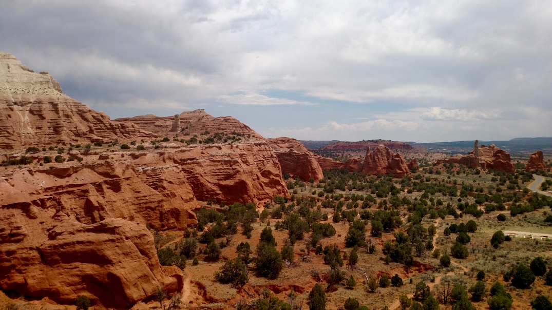
On a good day silence lays on Kodachrome Basin State Park like a blanket. Consider Kodachrome a quiet alternative to Bryce Canyon National Park, which is only a little more than 20 miles away.
When the scenic overlooks at Bryce get packed, you can always hop onto Utah 12 and drive towards Cannonville, past lonely ranches that sit beside fields of alfalfa. Just past Cannonville, the road spills out into Kodachrome.
Unspoiled desert surrounds visitors in Kodachrome. Your eyes sweep easily across the park’s flat basins dotted with sage scrub and juniper trees up to an unobstructed blue sky filled with cotton candy cumulus and rosy sandstone cliffs.
When the park is silent–and it often is–there is nothing to be heard, except when the wind blows.
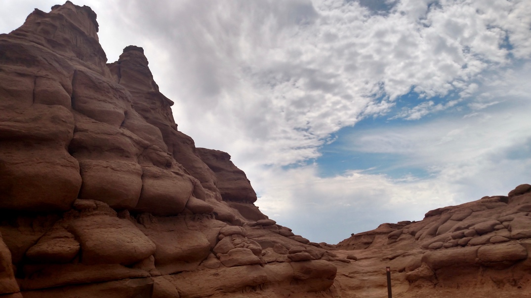
Unique geological features called sedimentary pipes, pillars or chimneys are found throughout Kodachrome. More than 60 of these formations populate the park, and they can’t be found anywhere else in the world.
Geologists still speculate how the chimneys formed–some theorize that seismic activity was involved.
The pipes reach for the sky in the flatlands and from the cliffs like huge industrial earthen chimneys.
Kodachrome got its name from National Geographic explorers who photographed the area using Kodak film of the same name in 1949.
Writer and photographer Jack Breed was on assignment searching for unknown and unnamed geographical features when he and his expedition discovered arches, colored cliffs and those weird sedimentary pipes.
Breed thought it was just the perfect place for Kodachrome film, which revolutionized color photography.
Before Kodak created the film in 1935, taking color photographs was a long and laborious process that didn’t always produce great results.
Kodachrome revolutionized color film, and gained quite a reputation for its vivid colors and saturation.
The film became a favorite of National Geographic photographers and amateur photographers alike. Kodachrome film captured the Hindenburg crash, the Kennedy assassination in Dallas and countless family outings.
Ultimately, digital killed Kodachrome, and Kodak decided to discontinue it.
However, Kodachrome Basin State Park still bears the name of the film, with the approval of Kodak, of course. The name serves as a tribute to explorers and photographers in search of a world of vivid color.
Although Kodachrome offers horse rides, hiking and camping it’s relatively easy to avoid people there.
When I visited in early August with my father we didn’t see another soul besides the park ranger that greeted us at the entrance gate. The only other vehicle we saw in the park was parked inside the campground.
Animals can be as sparse as other people in the desert sometimes, especially during the heat of the day. Long-eared and gangly-legged jackrabbits bound in between sagebrush when the day is cool. Often, raptors can be spotted in the sky.
I was fortunate enough to watch a pair of golden eagles gliding along the rim of Kodachrome’s cliff. The huge birds shone in the sun, and it was so quiet that their cries carried all the way down to where I stood watching, binoculars in hand.